By Jerry Jordan, Editor
BEAUMONT, Tx. — Residents in Southeast Texas are preparing for the strongest hurricane to hit the region since Hurricane Rita in 2005 when high winds caused severe damage to the area’s infrastructure.
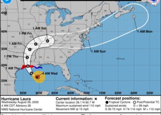
Hurricane Laura is predicted to make landfall sometime around 1 a.m. Thursday morning with a bullseye basically on Beaumont as a Category 3 storm, bringing with it a storm surge and minimum sustained winds of 111 mph. Category 3 storms range between 111 mph and 129 mph.
At 4 a,m, Wednesday, Hurricane Laura had reached 110 mph sustained winds and the track still has it hitting Southeast Texas late tonight or early Thursday.
The first mandatory evacuation order went into effect at 6 a.m. Tuesday morning in Orange County. Jefferson County followed up with a mandatory evacuation order that went into effect 30-minutes later. Hardin County Judge, Wayne McDaniel, called for a voluntary order at noon but by 2 p.m., he had changed the order to a mandatory evacuation.
Early Tuesday morning, a line of traffic was already starting to form and citizens were filling up their cars
NOTABLE LINKS FOR HURRICANE INFORMATION:
National Hurricane Center: https://www.nhc.noaa.gov/
Multiple Weather Links at Mike’s Weather Page: https://spaghettimodels.com/
TXDOT Emergency Evacuation Routes: http://gis-txdot.opendata.arcgis.com/datasets/txdot-evacuation-routes
TXDOT’s Drive Texas website for road conditions: https://drivetexas.org/#/11/30.3644/-94.3054?future=false
For updates and other evacuation information: SETINFO.ORG
EDITOR’S NOTE: We will be updating throughout the storm with information, photos and videos of the Southeast Texas region. Everyone, please stay safe!


